Cao Bang Loop Map: Route, Stops & Itinerary Guide

Plan your Cao Bang Loop with a practical route map created by BOSS Travel, a local tour operator based in Cao Bang.
This guide shows the main roads, attractions, recommended riding order and route options for travelers exploring Cao Bang by motorbike, Easy Rider or private vehicle.

Explore the Complete Cao Bang Loop Guide

3 Days 2 Nights – The Ideal Cao Bang Loop

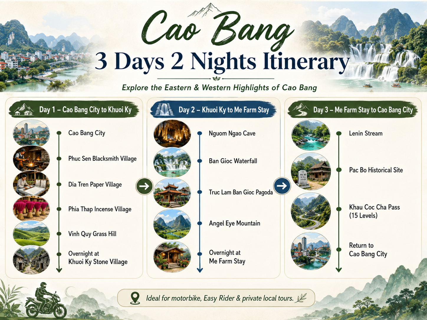
Three days and two nights is one of the best ways to explore Cao Bang at a comfortable and enjoyable pace. With our Cao Bang Loop Map, travelers can follow a well-balanced 3-day route that connects the eastern and western highlights of Cao Bang without spending the entire journey rushing from one stop to another.

The route combines some of the province’s most impressive landscapes and cultural experiences, including dramatic limestone mountains, scenic valleys, ethnic villages, traditional craft communities, waterfalls, caves, historical sites and spectacular mountain passes. Along the way, travelers can experience famous destinations such as Ban Gioc Waterfall, Nguom Ngao Cave, Angel Eye Mountain, Pac Bo Historical Site and Khau Coc Cha Pass, while also discovering quieter local villages and countryside scenery.

This 3-day itinerary is especially suitable for travelers who want to experience the best of the Cao Bang Loop by motorbike with a local driver or Easy Rider. It offers enough time for sightseeing, photography, local meals and overnight stays, while keeping daily riding distances comfortable and flexible.

For first-time visitors, 3 days and 2 nights provides an ideal balance between adventure, scenery, culture and travel time, making it one of the most practical ways to discover both the eastern and western sides of Cao Bang.

View 3-Day Cao Bang Motorbike Tour

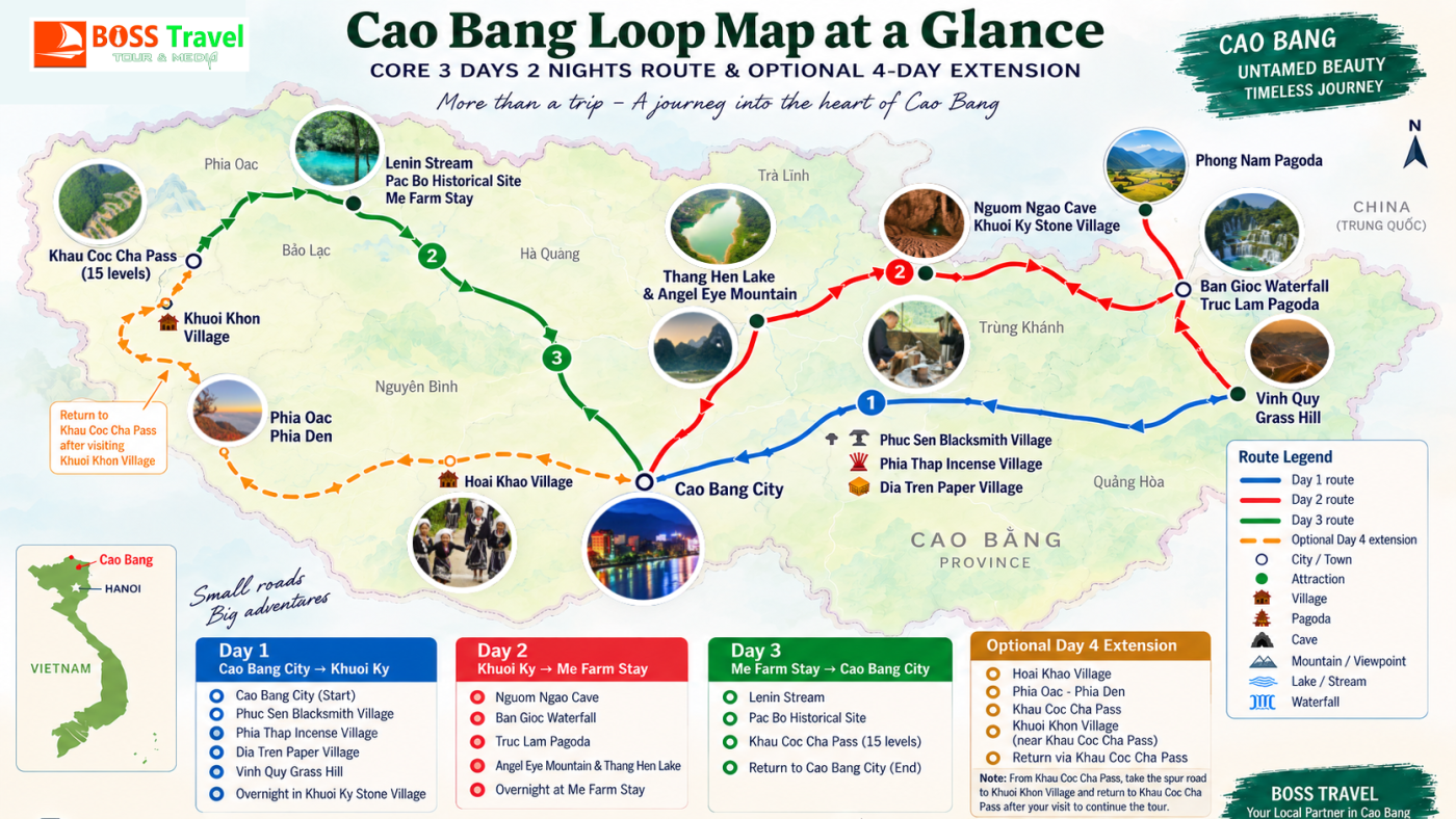
Cao Bang Loop Map – Core route and optional western extension.
Distances and travel times are approximate and may change with weather and road conditions.

Recommended Cao Bang Loop Route

For most travelers, BOSS Travel recommends exploring the Cao Bang Loop over several days rather than trying to visit every highlight in one long ride. The route below connects the main landscapes, historical sites and mountain roads of Cao Bang.

Need a day-by-day plan? See our detailed Cao Bang Loop itinerary for recommended 3-day and 4-day routes across Cao Bang.

Cao Bang Loop Route by Day

The following itinerary is designed for travelers who want enough time for sightseeing, photography, local villages and relaxed mountain riding.

DAY 1

Cao Bang City → Ban Gioc

Suggested route:

Cao Bang City → Ma Phuc Pass → Thang Hen Lake → Angel Eye Mountain → Trung Khanh → Khuoi Ky Stone Village → Ban Gioc Waterfall

Approximate distance: 100–120 km with sightseeing detours.

This is the classic eastern section of the Cao Bang Loop, combining karst mountains, valleys, traditional communities and the province’s most famous waterfall.

DAY 2

Ban Gioc → Pac Bo

Suggested route:

Ban Gioc → Nguom Ngao Cave → Phong Nam Valley → Trung Khanh / Tra Linh area → Pac Bo

Approximate riding distance: around 95 km depending on the selected mountain roads and detours.

This section moves away from the main tourist corridor into quieter northern valleys close to the Vietnam–China border.

DAY 3

Pac Bo → Cao Bang City

Suggested route:

Pac Bo → Lenin Stream → Coc Bo Cave → Ha Quang countryside → Cao Bang City

Approximate distance: around 55 km to Cao Bang City.

Spend the morning exploring Pac Bo before following the river valleys south toward Cao Bang City.

Main Stops on the Cao Bang Loop Map

Angel Eye Mountain

Known locally as Nui Thung, Angel Eye Mountain is one of Cao Bang’s most distinctive karst formations. It lies near the Thang Hen lake system and is an excellent scenic detour on the eastern route.

Ban Gioc Waterfall

Located on the Vietnam–China border, Ban Gioc is the most famous natural attraction in Cao Bang and one of the principal landmarks of the Cao Bang Loop.

Nguom Ngao Cave

Nguom Ngao Cave is located only a few kilometres from Ban Gioc Waterfall and is easily combined with Ban Gioc and Khuoi Ky Stone Village.

Khuoi Ky Stone Village

A traditional Tay community near Nguom Ngao Cave, known for its stone houses and peaceful rural setting.

Pac Bo Historical Site

Pac Bo combines important Vietnamese history with limestone mountains, clear streams and quiet countryside near the northern border.

Khau Coc Cha Pass

A dramatic series of mountain switchbacks in western Cao Bang. It is best treated as an extension of the core Cao Bang Loop rather than a quick detour.

Cao Bang Loop Routes by Trip Length

Choosing the right season can make a big difference to your route. See our Best Time to Do the Cao Bang Loop guide for weather, rice seasons, waterfall conditions and motorbike travel advice.

1 Day

Eastern Highlights

Cao Bang → Angel Eye → Ban Gioc → Nguom Ngao → Cao Bang

2 Days

East Loop

Angel Eye → Ban Gioc → Nguom Ngao → villages → Cao Bang

3 Days

Core Cao Bang Loop

East Cao Bang → Ban Gioc → Pac Bo → Cao Bang

4–5 Days

Extended Loop

Add Khau Coc Cha → Bao Lac → Phia Oac

Road Conditions, Fuel and Navigation

Most major roads between Cao Bang City, Trung Khanh, Ban Gioc and Pac Bo are paved, but conditions can change quickly in the mountains.

Heavy rain may cause landslides, loose gravel, mud or temporary road works. Smaller roads near villages and scenic viewpoints can be considerably narrower than the main highways.

Travelers riding independently should download offline maps before departure and avoid depending entirely on estimated Google Maps travel times.

Refuel whenever practical in Cao Bang City and district towns rather than waiting until the tank is nearly empty in remote mountain areas.

Before choosing your route, check our Cao Bang Loop road conditions guide for mountain passes, rainy-season risks and practical riding advice.

Local Route Advice

✓ Start riding early.

✓ Avoid remote mountain roads after dark.

✓ Download offline navigation.

✓ Check brakes, tyres and lights every morning.

✓ Allow extra time during the rainy season.

✓ Ask a local operator about current road conditions.

Cao Bang Loop by Easy Rider or Self-Drive?

Both options are possible, but the right choice depends on riding experience, licence requirements, weather and the route you plan to follow.

Easy Rider

A local driver handles the motorcycle while you travel as a passenger. This is the easiest way to enjoy the scenery without navigating unfamiliar mountain roads.

Best for: first-time visitors, non-riders and travelers who want local knowledge throughout the journey.

Self-Drive

Self-driving provides maximum independence but requires confidence on narrow, steep and sometimes wet mountain roads.

Travelers should make sure they meet Vietnam’s applicable driving licence and insurance requirements before riding.

How to Use the Cao Bang Loop Map

Do not treat the map as a fixed itinerary that must be completed in a certain order. Instead, use it to understand the geography of Cao Bang and choose the route that fits your available time.

For a short visit, concentrate on the eastern loop around Angel Eye Mountain, Ban Gioc Waterfall and Nguom Ngao Cave.

With three days, add the northern route to Pac Bo. With four or five days, continue west toward Khau Coc Cha and Bao Lac before returning through the Phia Oac mountain region.

For the complete planning guide covering routes, riding options, weather, safety and recommended tours, visit our
Cao Bang Loop guide.

Explore the Cao Bang Loop with BOSS Travel

Choose a local Easy Rider, motorbike tour or private trip and let our Cao Bang team adjust the route to your travel time and experience level.

Cao Bang Loop Guide 3-Day Cao Bang Motorbike Tour 2-Day Cao Bang Motorbike Tour WhatsApp BOSS Travel

Cao Bang Loop Map FAQs

There is no single officially defined Cao Bang Loop distance. A practical core route linking Cao Bang City, the eastern attractions, Ban Gioc and Pac Bo is generally around 280–320 km depending on detours. Longer western extensions can add substantial distance.

Three days is a good minimum for the core route. Four or five days is better if you want to include Khau Coc Cha, Bao Lac, Phia Oac or additional village experiences without rushing.

Most travelers start and finish in Cao Bang City, where motorbike rentals, accommodation, bus connections and tour services are easiest to arrange.

You can visit some eastern highlights in one day, but it is not realistic to experience the complete Cao Bang Loop properly in a single day. A one-day route is better focused on Angel Eye Mountain, Ban Gioc Waterfall and Nguom Ngao Cave.

Khau Coc Cha is commonly included in extended Cao Bang Loop itineraries. Because it lies in western Cao Bang, it is better planned as part of a four- or five-day route rather than added to a short eastern loop.

An Easy Rider is not mandatory, but it is a practical option for travelers who are not experienced mountain riders or who prefer to focus on the scenery while a local driver handles navigation and road conditions.

Ready to Plan Your Cao Bang Loop?

Use this map to understand the route, then explore our complete Cao Bang Loop guide for itineraries, motorbike tours, Easy Rider options and local travel advice.

If you are comparing northern Vietnam’s mountain routes, read our Cao Bang Loop vs Ha Giang Loop guide to understand the differences in scenery, road style, crowds and overall travel experience.

Planning your travel budget? See our Cao Bang Loop cost guide for estimated expenses including motorbike rental, fuel, accommodation, food and entrance fees.

Coming from Hanoi? Read our Hanoi to Cao Bang Loop guide for sleeper bus, limousine, private transfer and arrival tips before starting your route.

Choosing how to ride the route? Read our Cao Bang Loop Self Drive vs Easy Rider guide to compare independence, safety, road responsibility and local driver support.

Once you understand the route, plan your overnight stops with our Where to Stay on the Cao Bang Loop guide, covering Cao Bang City, Khuoi Ky, Ban Gioc and other useful accommodation areas.

Planning to explore the route by motorbike? Read our Cao Bang Loop Motorbike Rental guide for bike selection, safety checks, licence requirements and border-area access considerations.

Explore the Cao Bang Loop